


-
Welcome!

Specializing in advanced mapping and analysis services, The Terra Alta Group is founded on the vision that maps and geographic data provide people with valuable information allowing them to improve communication, which leads to better decision making. Our group has extensive experience applying mapping and geographic analysis to a variety of industries.
Read More -
GIS & Mapping Overview

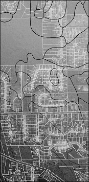
Mapping
We provide custom mapping, which includes aerial, parcel, land use, zoning, environmental and demographic maps.
Geographic
AnalysisWe can perform geographic analysis related to site selection processes, asset management, economic development, and environmental resource evaluations.

Data
ConversionWith our data conversion service, we convert your CAD or hard copy prints into informative GIS data.
We can also convert GIS data into CAD files.
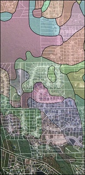
Web Mapping
We can assist clients in creating interactive web maps that can be created through ArcGIS Online, ESRI Web Apps or Google Maps. See Map Gallery
-
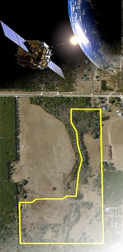
GPS/GIS Data Collection

Our group has had an extensive amount of experience in providing GPS/ GIS data collection. Data collection can be provided to organizations such as, utility companies, engineering consultants and municipalities. We can collect and deliver data from the field that is specific to our client’s needs.
Services- Asset Data Collection
- Stormwater Data Collection
- Field Research
- GeoTagged Photos
- Disaster Relief
AdvantagesGIS and GPS
GPS is a powerful resource which allows one to quickly locate features in the field and on a map. By combining GPS with GIS, users can gather the GPS location of a feature and record information about that feature at the same time. This creates a cost-effective data gathering tool, which significantly improves the quality of information used in decision making and data management. -
Database Design
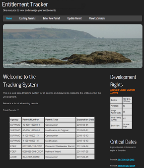
Our group can assist you in creating and managing databases that fit your need. We have experience creating GIS Geodatabases and standard databases such as My SQL and SQL. As an example, our group has worked to create permit tracking databases for development projects. We create customized web based tracking systems that allow our customers to monitor all permits and time sensitive documents. Our custom permit tracking systems can provide the following:
One source to view all documents
Alerts for expiration dates
Ability to update documents
View history of extensions
One resource to view and manage your entitlements
-
Contact Info
12443 San Jose Blvd. Suite 504 Jacksonville, FL 32223
Telephone: 904-288-6003
Brad England's Email: brad@terraaltagroup.com
-
Privacy policy
Lorem ipsum dolor sit amet, consectetuer adipiscing elit.
Praesent vestibulum molestie lacus. Aenean nonummy hendrerit mauris. Phasellus porta. Fusce suscipit varius mi. Cum sociis natoque penatibus et magnis dis parturient montes, nascetur ridiculus mus. Nulla dui. Fusce feugiat malesuada odio. Morbi nunc odio, gravida at, cursus nec, luctus a, lorem. Maecenas tristique orci ac sem. Duis ultricies pharetra magna. Donec accumsan malesuada orci. Donec sit amet eros. Lorem ipsum dolor sit amet, consectetuer adipiscing elit. Mauris fermentum dictum magna. Sed laoreet aliquam leo. Ut tellus dolor, dapibus eget, elementum vel, cursus eleifend, elit.Aenean auctor wisi et urna. Aliquam erat volutpat.
Duis ac turpis. Integer rutrum ante eu lacus. Lorem ipsum dolor sit amet, consectetuer adipiscing elit. Praesent vestibulum molestie lacus. Aenean nonummy hendrerit mauris. Phasellus porta. Fusce suscipit varius mi. Cum sociis natoque penatibus et magnis dis parturient montes, nascetur ridiculus mus. Nulla dui. Fusce feugiat malesuada odio. Morbi nunc odio, gravida at, cursus nec, luctus a, lorem. Maecenas tristique orci ac sem. Duis ultricies pharetra magna. Donec accumsan malesuada orci. Donec sit amet eros. Lorem ipsum dolor sit amet, consectetuer adipiscing elit.Mauris fermentum dictum magna. Sed laoreet aliquam leo.
Ut tellus dolor, dapibus eget, elementum vel, cursus eleifend, elit. Aenean auctor wisi et urna. Aliquam erat volutpat. Duis ac turpis. Integer rutrum ante eu lacus. Lorem ipsum dolor sit amet, consectetuer adipiscing elit. Praesent vestibulum molestie lacus. Aenean nonummy hendrerit mauris. Phasellus porta. Fusce suscipit varius mi. Cum sociis natoque penatibus et magnis dis parturient montes, nascetur ridiculus mus. Nulla dui. Fusce feugiat malesuada odio. Morbi nunc odio, gravida at, cursus nec, luctus a, lorem. Maecenas tristique orci ac sem. Duis ultricies pharetra magna. -
More About UsLocation based information plays a vital role in the day-to-day operations and success of many businesses. Geographic Information Systems (GIS) is a platform that helps businesses understand the geographical aspect of their business; however, many businesses don’t know about GIS and the benefits that it can provide to them. GIS software allows users to view, understand, question, interpret and visualize data in many ways that reveal relationships, patterns, and trends in the form of maps and reports. GIS helps to answer questions and solve problems by looking at your data in a way that is quickly understood and easily shared. The Terra Alta Group believes that the use of GIS can significantly improve a company’s operations. In addition to our geographic analysis services, we help our clients get their spatial data (maps) on the web by helping them create and manage interactive web maps. Using interactive web maps allows organizations to quickly share information. Web maps can be used to view and understand business data, manage assets or just share information.
The Terra Alta Group is owned and operated by Brad England.
Brad England, MBA, GISP, REALTOR ®
Brad England is a Geographic Information Systems Professional (GISP) with experience working in the land development in Northeast Florida since January of 2000. Areas of expertise includes due diligence mapping, market analysis, site selection assistance, permit tracking and ensuring the potential site meets the client’s desired finished product, which includes land use and zoning research in various markets in the region. Since 2004 he has performed GIS services in the Regulatory Planning Department assisting Regulatory Planners with completing the application process for development. Projects include residential, commercial, industrial, institutional and transportation projects. Instilled is a strong desire and drive to assist the client meet their long and short term goals and remain under budget.
Currently a Licensed Real Estate Broker in the State of Florida specializing in land sales as well as residential sales in Northeast Florida since 2003. Brad is continuously striving to build a strong client portfolio in an effort to form long term relationships. Brad continues to build on skill sets in an effort to remain well rounded in the GIS, real estate, and development industries.